Here are some of the snowfall totals for the Milwaukee area from Thursday morning; active weather pattern to continue
 Joe Taschler
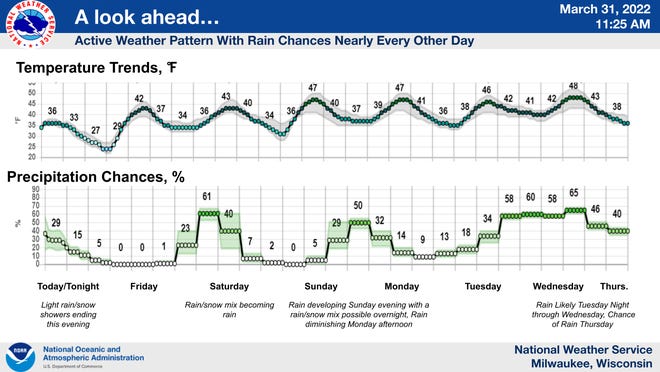
The snow that fell across southern Wisconsin, including parts of the Milwaukee metro, during the morning commute on Thursday occurred pretty much as expected, with snowfall totals falling on the low end of what was forecast.
As the storm approached, the forecast called for anywhere from 1 to 5 inches of snow. Warmer temperatures delayed the transition from rain to snow early Thursday and that kept snow accumulations on the low end, forecasters said.
Areas away from Lake Michigan saw the most snow, according to the National Weather Service.
Here are some snowfall totals from across the region:
- Sullivan: 2.8 inches
- Watertown: 2.7 inches
- Germantown: 2.6 inches
- Brookfield: 2 inches
- Oconomowoc: 2 inches
- Plymouth: 1.9 inches
- Madison: 1.7 inches
- West Allis: 1.5 inches
- Milwaukee Mitchell International Airport: 1.2 inches
Roads and highways across much of Wisconsin early Thursday were either snow covered or had slippery stretches as moderate snow was falling.
Once the snow moved out of the area just before noon, the snow melted from the pavement across the region. Grassy areas remained snow covered.
Early Thursday, numerous crashes and vehicles in ditches were being reported mostly to the north and west of Milwaukee where the highest snowfall totals were recorded.

The snow was the result of a powerful spring storm that moved across the nation's midsection.
In Washington County, sheriff's deputies, Wisconsin State Patrol troopers and fire departments were responding to numerous reports of crashes and vehicles in ditches, according to emergency radio traffic.
There were no immediate reports of any serious injuries.
The winter weather advisory that was in effect until noon Thursday for areas north and west of Milwaukee was allowed to expire.
Rain/snow chances almost every other day
The active weather pattern seen in recent days in Milwaukee and the surrounding region will continue into the upcoming weekend and into next week, said Rebecca Hansen, a meteorologist with the weather service in Sullivan.
Snow could mix with rain at times during the next few days, "but nothing like we saw this morning," in terms of accumulation, Hansen said.

The weather pattern should help to alleviate drought conditions across the region.
"We have a lot of ground to make up," in terms of moisture, Hansen said. "Every little bit helps."
"With this active pattern, hopefully we can chip away at that drought," she added.
Wisconsin weather radar

Can't see the radar? Click here.
Contact Joe Taschler at (414) 224-2554 or jtaschler@gannett.com. Follow him on Twitter at @JoeTaschler or Facebook at facebook.com/joe.taschler.1.